Contents of this Website are subject to Copyright © by Philip Strong, & allow fair academic use. See here.
1861 Griffith's Map
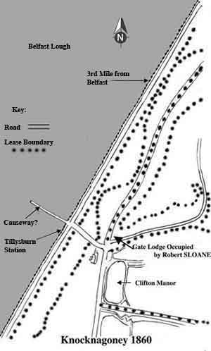 Diagram of the 1861 Griffith's map.
Source: Griffith’s Valuation: Map of Knocknagoney. PRONI VAL/2A/3/4. 1861.
This diagram from the 1861 Griffith’s map shows the relationship between the Robert SLOAN's gate lodge and Clifton House, variously referred in the 1861 Griffith’s records as Clifton Manor, Clifton Ville and Clifden. It also shows the nearby roads, boundaries of the leases, the Tillysburn railway station and a causeway(?) extending into the Belfast Lough. Con Auld suggests that the structure over the mud flats of the Lough (a causeway?), could have been used to collect green seaweed for crop fertiliser (July 2008; pers. com.).
Rejoin the Story
- Return to: Chapter 1: The story of Robert STRONG (Snr).
- Or continue on to: Chapter 2: The story of Robert STRONG (Jnr).